PR-C 160. Ruta de les Fonts
Circular route designed for both walking (more than 4 hours) and cycling. Proposed by BEC-CEB and catalogued as PR-C 160 by FEEC. It crosses the agricultural plain of Begues, passing by some farmhouses, heading towards Vallirana, in the sector of the serres d'Ordal. We will enjoy views over the town, the Vallès region, and the Baix Llobregat. In the higher areas, karst relief features like sinkholes and dolines stand out. In the plain, farmhouses, huts, and fields reflect the agricultural past that still endures.
We start a l'església de Sant Cristòfol, heading towards the farmhouses of can Martí and Can Pau, with their sundials. can Martí has a remarkable oak tree in its back courtyard.
Among cereal fields and a few vineyards, we head to the farmhouse of can Pau, at the foot of the karst slopes of the mountain range. We will see fields where we can stop and enjoy the spring blooms and small birds of open spaces. We observe poppies, wild tongues, and thistles, and also spot goldfinches and finches flying by. Jays and wood pigeons emerge from the nearby forest in search of grain and fruit in the fields.
A few meters past the farmhouse of can Sadurní, we pass by a lime kiln hidden to the right of the path. Next to the farmhouse, magnificent examples of wild olive trees offer their prized shade. From here, a postcard view of vineyards, fruit trees, and cereals, along with a stone hut, gives us a glimpse of the town's agricultural plain.
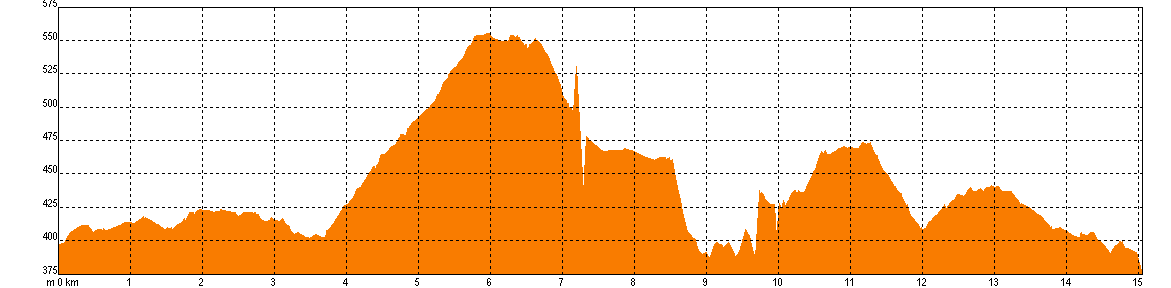
We begin the climb towards the pla d'Ardenya. Although longer, we recommend taking the paved road that leads up to the FECSA power plant. Alternatively, there is a shorter but more demanding option that rejoins this road just before reaching the can Sadurní sinkhole.
Climbing the road, which is longer but gentle, you will enjoy panoramic views of the town and the Parc del Garraf. We will pass by the can Sadurní sinkhole, and an indicator post marks the path down to the entrance hole.
Before reaching the power plant (from where we could ascend Montau), we turn right. We are at the top of the pla de sots d'Ossos. This karstic area features the large doline of the Alzines sinkhole. We cross a vegetation formation of the maquis type, with holm oaks and mastic trees. It’s not unusual to spot large raptors, both during the day and towards evening, as we are in the territory of the vultures and Bonelli's eagles.
Arriving at the Creu d'Ardenya, we head towards the pla d'Ardenya, where the presence of stone pines among the dominant white pines is surprising. From here, the ancient route leads down to Begues, should we need to return.
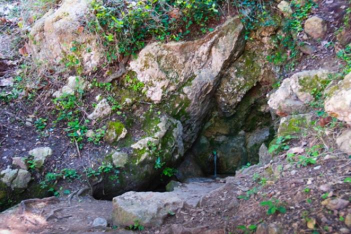
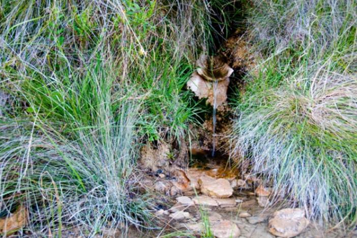
We circle around the la serra del Mas, passing by a ruined farmhouse. Next, we descend towards the mas de les Fonts farmhouse. The first spring is located beneath a row of plane trees. Now, on our way back to Begues, new views of Montserrat will appear behind us, stretching towards Barcelona.
Passing by the coll del pi de les Tres Soques, it’s worth detouring a hundred meters to check out the viewpoint at Penya del Moro. This is part of the Route del Sol Blau PR-C 162, which links to the municipality of Torrelles.
Now, on the descent, we pass by the Font de l'Àlber, where a poplar tree on the left side of the path marks the location.
Back on the plain, now crossing orchards, we pass the farmhouses of Farfai, Alzina (where the old irrigation wheel still remains unused), and Casota, with its sundial.
Before returning to the starting point, it’s worth visiting the recently restored barraca de Cal Tot.
Source: Ajuntament de Begues.
Technical sheet


Route
- Easy to do by mountain bike. Medium difficulty for walking. Always on a wide track, except for the small path behind cal Gepet and can Sadurní.
- Comfortable but long initial climb. If walking, you can take the first shortcut on the left to go almost directly to the top. You will miss the views of the town.
- At the top of the FECSA power plant, you can decide whether to climb Montau. It’s a steep ascent.
- You will reach the Creu d'Ardenya while walking along the flat. If you want to return to Begues, take the path on your right. The middle path climbs to the top of Sotarro (steep ascent).
- Around the Creu d'Ardenya, between the path leading up to Sotarro and the one descending to Begues, there is a supposed dolmen. You’ll find a scattering of stones (you can locate it on Google Earth).
- When reaching Peña del Moro, it’s worth deviating a bit and peeking at the viewpoint. The cliff has a climbing area, and access to the lower part is prohibited due to bird of prey nesting.
- At the top of Penya del Moro and below, near the farmhouse of Alzina, you will find links to the Route del Sol Blau PR-C 162, which connects to Torrelles.
Water
- The only water available is la font del Mas. Of the two fountains there, the first one usually flows right on the ground.
- The Font de l'Àlber only flows during rainy seasons.
Precautions
- Be careful when approaching the entrances to the sinkholes if you are with children.
- Avoid the central hours of summer since there is little shade. Don't forget to stay well-hydrated and use sunscreen.
- If you choose to walk, bring energy food.
- None of the sinkholes can be entered without specific equipment and being accompanied by experienced people.
Equipment
- If walking, trekking poles will help on long walks.
- Footwear doesn’t need to be too technical, but it should be comfortable and durable.
- Binoculars, in case you spot raptors or other birds of open spaces.
- A map of the area will help us orient ourselves and better understand the route.
- If you’re doing the route by mountain bike, don’t forget puncture repair materials. There are sections with angular gravel.